
It’s the end of the summer. In fact, it’s practically the end of fall. In what seems like just moments, we will be in the midst of another seasonal transition—there’s a far-off future with jobs, people, and places we can’t even picture yet. John and I had a final weekend to take advantage of and a milestone birthday to celebrate, so we went for the extreme: the northernmost incorporated city in America.
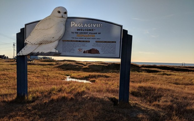
Utqiagvik (UUT-kee-AH-vik), Alaska—once known as Barrow, but now officially reinstated to its original and native name—is a community of 4,000 people that sits on the Arctic Ocean 320 miles north of the Arctic Circle. There are no roads outside of the town, so anything that comes in or out has to be by air or ship. The Iñupiat, an indigenous Inuit ethnic group, have been subsisting on the land there for more than 1,500 years; they harvest whales, hunt other mammals such as caribou, and fish to survive the harsh arctic climate. Despite the cool temperatures, it was also one of the warmest communities I have ever been to.
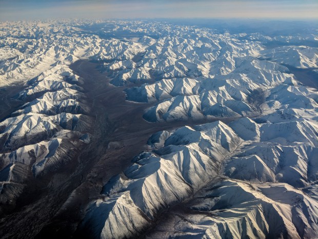
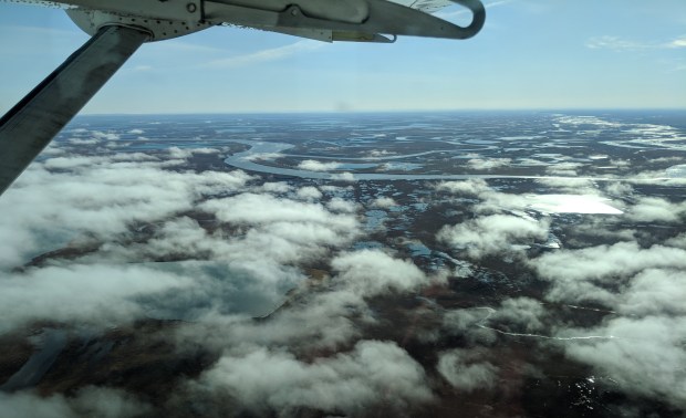
On September 7th, we boarded a deHavilland Dash-8 on the tarmac at the Fairbanks Airport. We were two of 5 passengers headed to our first stop, Prudhoe Bay. Also sought after for its northern location, some travelers access Prudhoe Bay via the Dalton Highway, which begins north of Fairbanks and runs all the way up. On the first hour-and-40-min leg of our flight, we passed over the Brooks Range, the northern mountain range in Alaska that separates the Interior (where Denali is located) from the North Slope. I looked down at the snowy peaks in wonder, grinning from ear to ear as we flew over the widest band of mountains I had ever seen.
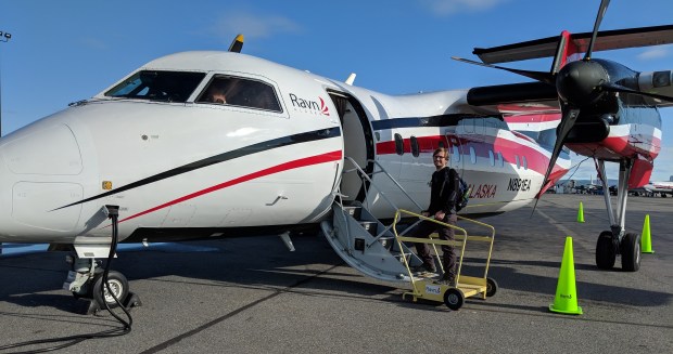
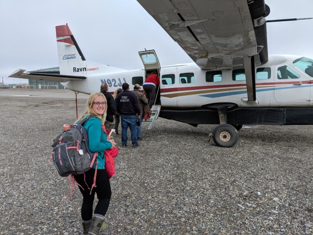
In Prudhoe Bay we boarded a smaller, 7-passenger Cessna to Utqiagvik, flying over expansive wet tundra for another hour or so as we neared the north of the country.
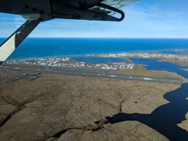
Finally we saw the small community hugging the Chukchi Sea and landed on the airstrip at the southern edge of town. The walk to our hotel along the dirt roads was only 5 minutes, and we were greeted warmly by the front desk staff. The skies were clear and the sun shone boldly upon the treeless land, warming the air to around 45°F. A perfect night for a walk!
We quickly experienced Utqiagvik’s charm and character. At Sam and Lee’s—the local Chinese restaurant/pizza parlor—each entree was $20. Most houses look rundown on the outside, there are old cars and parts and wood piling up in everyone’s front yards, yet most of the cars in driveways and on the roads are new. A 12-roll pack of toilet paper costs $20. The closest other village is miles away, which means community understanding and teamwork is a necessity here.


We continued our walk through town to an ancient site near the ocean, where mounds of houses from 500-700 AD could be seen, collapsed and returning to the earth. The homeowners used whale jaw bones to reinforce the doorway into their homes, and we could even see pieces of these bones as the shoreline was sloughing into the sea.


The next morning we were treated to some of the best homemade bread I’ve ever had, courtesy of our hotel. We walked down to the beach again and bought some patches and postcards to take home. The water was cold but beautiful, with white foam collecting on the dark sand.


At 11:30am we made our way to the Top of the World Hotel (which costs three times what our hotel did) to check in for our tour. There were a total of 6 of us signed up and they split us into 2 tours, each group of 3 in a 15-passenger van. Our guide’s name was Jimmy: a 21-year-old Alaska Native born and raised in Utqiagvik.
There are too many stories to share fully, so here are some tidbits we learned while exploring the town with our guide:
- The edge of town along the Chukchi Sea is lined with piles and dunes of sand, which in case of storms, which will buy the town time to move their heavy construction equipment now stored there farther inland.
- They use an incinerator to burn their trash.
- There’s a college! It’s called Ilisagvik, which means “a place to learn”. The campus is located just north of town and serves 500 students each semester, where they can learn carpentry, welding, business, information technology, or even get their CDL!
- The high school football team’s first home game was played on a flattened area of gravel with flour for lines, created by some high school seniors. ESPN aired the event and the Seattle Seahawks flew them to Washington. They donated gear for the team head-to-toe and even a brand new, yellow and blue turf—the color of their home team, the Whalers. (Once a polar bear even appeared for the game—the other team headed for their team bus and forfeited.)
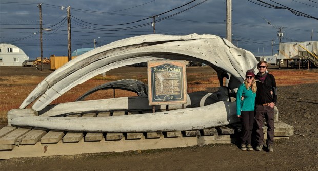
This is the skull of a bowhead whale, which can grow up to weigh between 75-100 tons!
Speaking of whaling—it’s a practice that has been a part of Utqiagvik since its first human settlement. The Iñupiat usually head 30-40 miles offshore to hunt whales. A single harvest could feed the entire community for a year and it takes the entire community to make the tradition happen. There are 51 whaling crews that will head out, each with their own flag to signify their team, and 24 whales can be taken per year. Because of the paths of whale migrations, Utqiagvik is the only community in the North Slope that hunts in the spring and the fall, though fall whaling is generally run slightly different from the spring because of the lack of sea ice near shore. Whales have even been found with stone harpoon tips inside of them, and the wildlife department of Barrow found the oldest whale harvested to be more than 250 years old!
Halfway through the tour, we walked part of the rocky beach near the northernmost section of road in the US. In ten minutes of walking, John and I found a tooth, a piece of volcanic rock, and a couple of pieces of very old bone!


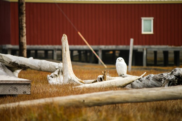
We spent an hour and a half at the Iñupiat Heritage Center, which had an amazing exhibit on whaling. John and I walked out behind the museum for some fresh air, and out on the tundra grass saw our first snowy owl in the WILD! I was ecstatic, and John and I were able to get some cool photos. We continued the tour to the end of the road system about 10 minutes outside of town, and saw 2-3 more snowy owls and even an arctic fox!
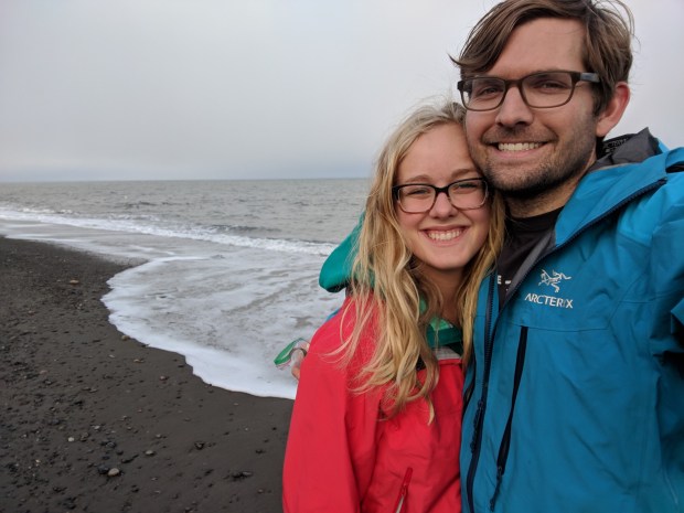
Then, it was time. We drove back to a beach near the hotel and started stripping our clothes off into the sand. Ready to be back in the warm car, I was down to shorts and a crop top quickly, with John lagging behind in his full cold-weather attire. Before I knew it, we were running towards the Arctic Ocean, limbs flailing behind us.


The water temperature hit me like a ton of bricks—I was up to my waist before I knew it, and my breathing quickly became shallow and difficult. I turned back towards shore and saw John dunk underwater. I plugged my nose and did the fastest dip my body would allow, then immediately bolted for the sand, with John right beside me. We grabbed towels from our guide, shrieking and laughing as we tried to dry ourselves off and warm up. It was truly a once-in-a-lifetime experience.

")

That night we ate leftovers in the hotel room, played a board game, went out for late pizza, and watched the sun set over the Arctic Ocean. A wonderful end to an unforgettable trip, and an even more unforgettable birthday for John.
Mission accomplished.
Until next time,
Lindsey

Lindsey, what a great adventure and awesome photos! There never seems to be a dull moment in your life … what a wonderful way to live a real life! Keep it up!
Uncle Rich
LikeLike
Fascinating!!!! Thanks for sharing. We’re definitely moving it up on our list of places to visit!
LikeLike
Thank you for reading, Patrice! It means a lot to me! 😊 I hope you and Justin are doing well!
LikeLike
Oh my Lindsey! Such wonderful photos to go along with your great writing! I love how you mix your personal experiences with alittle history. So fun to read! I miss you sweetie! ❤️ Barb
LikeLike